Texas Stages Development of Statewide Flood Plan
About the author:
Carol Brzozowski is a freelance writer for Water & Wastes Digest. Brzozowski can be reached at [email protected].
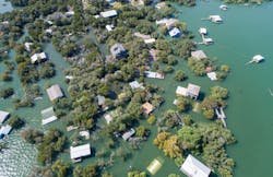
Stantec recently initiated a statewide floodplain modeling and mapping project with The Texas Water Development Board (TWDB) as part of its effort to evaluate regional flood risks driving statewide efforts in creating effective flood mitigation strategies. It is the first statewide flood plan for Texas.
An increase in extreme weather events such as Hurricane Harvey and others underscore the importance of understanding statewide flood risks. TWDB aims to lead the state’s efforts in promoting a secure water future for Texas, including incorporating the development of regional flood plans into the statewide flood plan.
Stantec is one of five organizations partnering with the TWDB to develop base level engineering (BLE) floodplain modeling and mapping studies as part of a multi-year effort that will include key components such as two-dimensional riverine model development, hydrologic and hydraulic assessments, and flood hazard mapping.
Stantec has modeled more than 15,000 miles of BLE projects nationwide. The company serves as a national Federal Emergency Management Agency (FEMA) Production and Technical Services (PTS) contractor, having performed more than 60,000 miles of floodplain analyses across 34 states.
“There’s an old idiom in planning that a problem well-defined is half-solved,” said Ryan Murdock, Stantec vice president and water resources practice leader based in Austin, Texas.
“Analyzing flood risk and the underlying data in a state as large, diverse, and dynamic as Texas is no simple task,” said Mason Liebau, project manager for Stantec.
A Push for Change
The driving factor for the project came in 2019 when the Texas Legislature and Governor Greg Abbott expanded TWDB’s role in flood planning and financing. Monies were allocated to the Texas infrastructure resiliency fund to update flood risk maps for the entire state to support the development of the first statewide flood plan.
“These models will be the base for the planning side of the work that the Texas Water Development Board is doing,” Liebau said. “They may be looking more into flood proofing and flood reduction type projects that might service some of the water and wastewater industries.”
Part of the effort is to have coverage of the flood risk assessment in a consistent manner across the entire state of Texas that is based on updated technology and the “latest and greatest information” so that planning decisions can be made based on comparable and consistent information, Murdock said.
“When a community applies for flood mitigation funding, it’s going to provide this much benefit," Murdock added. "They may be trying to compare that proposal for a grant application. They know that they're comparing apples to apples, and their communities are being essentially treated comparably and it's based on the latest and greatest information available.”
The project will go a long way in helping smaller communities that do not have the resources to invest in such risk mapping, Murdock noted.
“Larger urban communities are the ones investing in some of the detailed flood mapping and studies as they have more developers coming in and they need to understand those risks,” he added.
Impact on Small Communities & Utilities
A challenge in Texas is that there are many small communities in a watershed and flooding does not respect municipal boundaries.
“Something that’s really helpful is that the state Legislature and the board have been very proactive,” he adds. “This provides an even playing field for everyone to understand their level of flood risk regardless of whether you're in a major metropolitan area or in a more rural area that may have repeated flooding. It provides everyone the same access to information on a statewide basis.”
Murdock pointed to numerous studies updating rainfall intensity as a crucial transparent data set. The NOAA Atlas 14 Precipitation Frequency Data Server rainfall studies, for example, updated older approaches, models and rainfall patterns in the past to reflect the current reality of the greater risk that now exists.
“A lot of it in the world we live in is understanding a consistent level and manner of communicating flood risk and this can be used to both have a consistent data set across the board but also be uploaded and shared with FEMA, USGS and others in such a way that communities across the state regardless of the level of their funding can have access to this information,” he said.
The project is supporting FEMA efforts by the uploading of the work to the Risk Mapping, Assessment and Planning (Risk MAP). The information also will be on the Estimated Base Flood Elevation Viewer.
“A lot of the tasks we’re doing also are on the USGS Flood Decision Support Toolbox,” Liebau notes.
A Blueprint for the Future
The planning process serves as a blueprint for future project implementations.
“The board is trying to get their hands around understanding this consistent level of flood risks statewide,” Murdock says. “They’ll be able to look at looking at flood mitigation actions in different areas that have higher risks. The board is moving forward very rapidly with their flood plans, but also this flood mapping in parallel tracks. Once it is done, it’ll be reintegrated more formally into the planning process that they're doing as well.”
Legislative deadlines call for the completion of the modeling by 2024 at which time the first set of plans is expected to be completed.
“It’ll also be more accessible for use in the next round of the plans as well, which will then look towards understanding those risks and identifying projects to mitigate specific flood risks in certain areas,” Murdock said. “The board and Legislature are to be commended for taking a very proactive approach and putting the appropriate funding forward. It’s easy to react to crises, but the board is taking a meaningful step forward and trying to do true planning that can lessen the impact of future flooding events, which we know will continue to happen.”
About the Author
Carol Brzozowski
Carol Brzozowski is a freelance writer for Wastewater Digest. Brzozowski can be reached at [email protected].