Capturing Every Last Detail
Puppala is a distinguished professor in civil engineering, and Chandra is a doctoral student in civil engineering, both with the University of Texas at Arlington.
undefinedThis article originally appeared in Technology Today, a supplement to Roads & Bridges. You can access the original version of this story on the Roads & Bridges here.
Transportation infrastructure relies upon pavements, bridges, railways and airports, forming the backbone of every nation’s economy.
Longevity of civil infrastructure is dependent on different factors, such as the loading and environmental conditions, utilization rate, and frequency of disasters/emergencies. Timely, proactive maintenance of infrastructure will assist in enhancing the longevity of infrastructure with minimal maintenance costs. Most of the traditional methods for evaluating the infrastructure condition are subjective, time-consuming, require more personnel in the field, and may compromise worker safety due to the need for potential interactions with live traffic. Hence, there is a huge need for formulating a methodology that will offer quick, repeatable and reliable, as well as palpable, data in a safe manner.
Recent advancements in unmanned aerial vehicle (UAV) platforms complemented by the development of sensors, including photogrammetry-related cameras, have contributed to the development of these UAV technologies for potential applications in infrastructure management. The flexibility of operating UAVs either manually or automatically gives scope to monitor and assess conditions of various infrastructure elements including those located in the hard-to-reach locations such as bridges in hilly terrains or in river or stream environments. Accessibility to mark precise location data by global navigation satellite systems (GNSS) will provide high-quality data that will be valuable in tracking and monitoring the health conditions of the civil infrastructure.
What is CRP?
Photogrammetry is the art and science of remotely estimating measurements from two or more images. It can be accomplished with platforms ranging from terrestrial to aerial systems with sensors as various as a smart phone camera to sensors mounted on a satellite. Close Range Photogrammetry (CRP) is a subsidiary of photogrammetry that collects the infrastructure data within a 1,000-ft distance from the sensor platform. Unmanned Aerial Vehicle-Close Range Photogrammetry (UAV-CRP) technology is comprised of DSLR cameras mounted on the UAVs that fly over the infrastructure to image the terrain and structures from various angles.
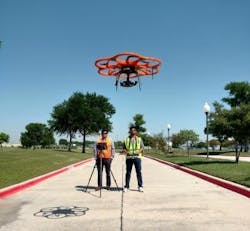
The University of Texas at Arlington (UTA) research team has received a major grant from the Texas Department of Transportation (TxDOT) for comprehensive evaluation of UAV-CRP technology to monitor the infrastructure at various project sites in the state of Texas. The research team has employed different sensors on a Hexacopter and a quadcopter to evaluate the initial applications of UAVs for health monitoring of infrastructure and estimating stockpile material volumes. The data collection was performed by a Federal Aviation Authority (FAA)-certified pilot and visual observers following the field operation principles developed in the Flight Operations Manual (FOM). The UTA team assisted TxDOT in validating FOM manual protocols by providing suggestions based on FAA guidelines and performing field UAV studies.
For pavements, the International Roughness Index (IRI) parameter is typically determined using the golden car method that accounts for the longitudinal elevation profile of the pavement section and pavement undulations experienced by service conditions. This parameter is traditionally measured using laser-based profilers. Cross-slope of the pavement is another important parameter to ensure ample drainage conditions of a pavement section that will reduce ponding problems at a site, which contributes to pavement distress. At turns, it also is necessary to check if there is sufficient transverse slope, i.e., super-elevation providing necessary centripetal force for a safe turn. Although the above pavement characteristics can be estimated using traditional methods, more than one method is needed for estimating all these parameters. Additionally, the data obtained by these methods may not be palpable.
UAV-CRP technology could be used to measure various characteristics and distress of pavements that will help in assessing the ride quality and safety conditions offered to the traveling public. UAVs could be used to collect the longitudinal and transverse elevation profiles by taking off and flying away from the pavement section with an inclined camera facing towards the pavement section.
On Location
As part of the TxDOT-funded research, UAV operations were performed adjacent to U.S. 82 near Sherman, Texas. Due to the vegetation along the pavement shoulder, a large wooden plank was placed and used as a take-off and landing platform. No traffic regulations were imposed while collecting the data from the drone, and all the protocols related to live pavement UAV surveys were followed. Also, the camera angle was obliquely inclined towards the pavement section while flying at a lower altitude and in the nadir position while flying at higher altitude; this was to ensure full transverse coverage of the pavement section. Data collection was only conducted on one side of the pavement section. The collected pavement image data was then used and processed to develop dense point-cloud models and orthophotos to evaluate pavement distress features.
Three-dimensional dense point-cloud models were able to capture the minute details of the pavement surface condition representing its original existence in the field. More than 10,000 points were placed along the five paths along the longitudinal direction of the 300-ft-long section of the pavement. These longitudinal profiles along the pavement were used to estimate the IRI values, which were then used to estimate and compare the riding comfort experienced by the road users. The IRI values determined from UAV-CRP studies are in good agreement with those measured from profiler surveys. This analysis indicates that UAV-CRP can be used to determine the approximate IRI values of the pavement sections.
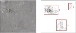
Distress parameters including longitudinal and transverse cracks of the pavement, surficial undulations and other cracks, including fatigue and material cracking, were captured and analyzed. Algorithms developed by the research team were able to identify cracks in the captured images distinguishing hairline cracks to heavily distressed cracks. Figure 1a shows various cracks on pavement surface layers. The heavily distressed cracking Region 1 in Figure 1a is strikingly identified as in the algorithm-processed image in Figure 1b. The lightly cracked Regions 2 and 3 are hardly discernable to the naked eye, and this is the aspect where these innovative technologies fare better than a simple visual inspection by identifying these minor cracks. These minor cracks transform onto heavily distressed areas with time, and early identification of these cracks will help in planning for preventive maintenance.
Identifying hairline cracks will lead to proactive monitoring and maintenance strategies as this data will help in quick repairs when the distress problems are at very early stages—in advance of their becoming major maintenance issues. The extent of other distress areas computed from UAV-CRP-collected data will help in estimating the present serviceability index parameters, thereby assisting in the decision-making for pavement rehabilitations. Thus the UAV-CRP methodology will help in transforming the present subjective inspections and assessments to objective assessments by providing repeatable and reproducible data in a short time with high safety features. Traffic controls for field studies will be minimal, and this saves significant taxpayer dollars—savings that could be applied to proactive rehabilitation assessments and repairs.
Pavement characteristics including cross slopes in the transverse direction can be determined using the same collected field data. For better computation, the cross slope was estimated with points placed at 1-cm intervals in the transverse direction of the pavement. Analysis of the pavement characteristics data collected from UAV-CRP technology also proved to be efficient and accurate when compared with the corresponding traditional methods. This also indicates that this technology could be used at the time of new construction of pavements, as these parameters will be used as part of quality control and assessments of construction processes adapted in the field.
What It’s Good For
The UAV-CRP technology can be used for monitoring the volume of infrastructure construction materials. This will help in timely project planning and construction tasks. Material stockpile volumetric information provided by this innovative technology can be quick, efficient and accurate. Conducting repetitive data collection using similar or identical flight plans at regular time intervals will give an estimate of the material being used, and this information can be correlated to the progression of construction work on a given project. This would result in lesser construction delays as material replenishment can be done on a regular basis as well as lesser stockpile survey measurements needed during the construction periods. This technology is forecasted to be an integral part of every project management team, as it offers scope for quick and more realistic estimation of the infrastructure materials during construction.
Last but not least, the UAV-CRP technology can be used to perform annual bridge rating surveys as well as QC/QA works in new bridge construction. A 360° bridge inspection was carried out on a new bridge section which is yet to be opened for traffic. This section was built as an extension of SH 360 in Mansfield, Texas. The superstructure was inspected for evaluating the infrastructure conditions of the bridge deck, approach slab, railings, and joints and bearing material conditions. The substructure also was surveyed and inspected for the condition of the beams, soffits, bearings, wing walls, abutments, pile and cap, as well as the pile footing. The side and the deck elements of the bridge were inspected using a camera mounted on a bottom gimbal. The underneath bridge section was inspected using the top gimbal of the UAV.
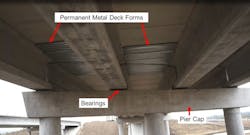
The processed image outputs of the superstructure were analyzed for different features including the condition of the bridge deck, railing, joint width, and other bridge elements. Due to lack of GPS signals, the under-bridge inspection was carried out by flying the hexacopter manually, as it was important to approach this part of survey with more caution. Throughout the bridge inspection, a live feed of the camera view was relayed onto a digital live video display (DLVP) unit stationed on the ground. (This aids the bridge inspector, if present at the site, to instruct the pilot to inspect the desired bridge elements. Also, high-definition quality videos of hard-to-access bridge elements will help the inspectors to have an infield inspection view even sitting at his/her office.) The under-bridge view from the copter shown in Figure 2 gives an idea about the condition of the bearings, soffit, permanent metal deck forms (PMDF), pier caps, and other elements. UAV-CRP technology also minimizes the traffic-control restrictions needed when compared to the traditional way of conducting under-bridge inspection using a snooper truck.
Starting from early monitoring during the construction stage to the in-service state of the infrastructure ensures proactive inspection and repairs, and thus enhances safety for infrastructure users. This also will result in significant cost savings for agencies’ allotment of infrastructure maintenance dollars. Hence, availability of efficient and proven UAV-CRP technology will help in preventive maintenance of the infrastructure, thus enhancing the pavement and bridge preservations. A readily available inspection tool, with minimal maintenance costs over the long run, will outweigh the initial capital costs of the UAVs and accessories. This makes it more convenient and practical to conduct or perform regular survey inspections. In addition, the safety of the working UAV personnel will be ensured by keeping the pilot and the visual observers away from live traffic situations in most instances while conducting the UAV-CRP monitoring and surveying studies.
Acknowledgments: The UTA research team acknowledges the research funding support provided by TxDOT and thanks Joe Adams, Jay Joseph, Jonathan Martin, Arturo Perez and many others for their assistance with the research tasks.


