One of the biggest challenges the nation faces is its aging water and wastewater infrastructure, which needs to be repaired or replaced. The American Society of Civil Engineers’ (ASCE) latest Report Card for America’s Infrastructure, which is issued every four years since 2001, gave the nation’s water systems a D grade and wastewater systems a D+ grade.
American Water works with local communities to identify problem areas, helping them plan where and when to proactively replace and upgrade their infrastructure. For customers, it means improved water quality, service reliability and fire protection.
American Water also works closely with customers to help provide operators with a deeper understanding of what customers want and expect from their water service provider. As the utilities sector enters a new era, customer engagement is not only encouraged, but also expected.
Engaging the Customer Base
American Water conducts focus groups with customers in different parts of its service areas nationwide, with the goal of learning about the perceptions of the value of the water and the value of the services it provides, as well as what information the public wants to know, what it finds useful, and what sort of messages help it understand water service providers.
Beyond an understanding of what they pay for each month, customers also want tips and information they can use, and they want to know more about what water service providers do for their communities. It is not enough to say the provider cares; customers want to see the ways the provider cares.
Implementing GIS
American Water began brainstorming ideas on how to use geographic information system (GIS) tools to improve interdepartmental and customer communication of utility data. External affairs and engineering collaborated to use ESRI StoryMaps to share the investment American Water is making toward pipeline replacement. The team found this was a tool it was excited to implement to benefit customers and the utility.
In 2016, American Water invested approximately $1.5 billion—the most in its history—into infrastructure improvements. Of that amount, $1.3 billion was invested in regulated systems to improve service reliability and water quality for customers. Those investments will continue, as more than $6 billion is slated for further improvements in the next five years.
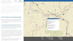
With these investments in new technology, customers can view details about infrastructure projects and other capital investments with an interactive map launched by American Water subsidiaries in New Jersey, Pennsylvania and West Virginia. The maps are located on the subsidiaries’ websites.
Often, customers do not see how their water bills translate to capital improvments because upgrades to infrastructure may not occur in front of their home, or it may not be obvious that nearby construction work is a water system improvement. To the casual observer, such improvements look similar to a sewer, natural gas or road improvement. While communicating major infrastructure investments to customers through mailings and press releases is useful, the GIS map takes the next step to provide details about all current projects statewide, and it is accessible from any computer or smartphone.
The maps allows customers to view details about specific projects in their town or country.
Benefits
With this user-friendly map, customers can view details about the company’s water and wastewater pipe renewal or replacement projects across its service areas in the state. The map features summaries of pipe upgrades across the state, total dollars invested and length of pipe being installed. By clicking on individual projects, users can see specific project details and view the street-level details of projects in their town or county.
The future of these GIS tools has even more potential than simply mapping infrastructure improvements for public record. They also can be used to convey and evaluate utility data, which can be valuable for business. Implementing this system is a step toward better customer engagement about how their bills are spent and what projects are being completed near them. This transparency is critical for improving the systems and striving to earn and keep customer trust as their water services provider.


